From a couple of weeks Galileo has started to be operative, the new European satellite navigation system. But why is it so important? It was not enough GPS? Unless you have a particularly developed sense of orientation and you usually rely on satellite navigation even for small daily commute, we should hope for a lasting peace between the United States and the former Soviet bloc.
Because the GPS system (Global Positioning System), that we all use every day by car, by bike, while trekking or even for work, was created and is still run by the Department of Defense with stars and stripes.
HISTORY. Inaugurated in 1978, it is built up by 27 satellites and a complex network of ground infrastructure, which allow the various devices to know in every moment where they are with an accuracy of a few dozen meters (10 to 30 depending on the signal strength and to possible interference).
THE SOVIET RESPONSE. In the middle of the Cold War, the USSR could not stand to watch: for this reason in 1982 launched into orbit the first satellite of the GLONASS project, the equivalent of the GPS system. Consists of 24 satellites, became operative only in 1995. Today, most smartphones and other devices equipped with satellite positioning system, can use either GPS or GLONASS.
It is efficient technologies, reliable and free, but it is hided a potential risk: being run by military structures, can be turned off or altered in case of conflict with the aim to create difficulties the enemy.
The latest incident dates back to 2014, when the Kremlin threatened to turn off the GPS ground stations located on Russian soil, in
response to war about the annexation of the Crimea.
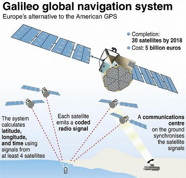
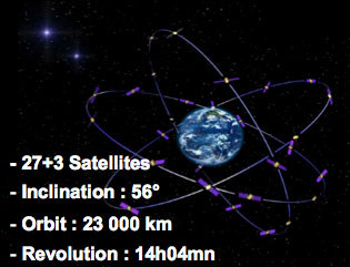
GALILEO. But the things could change soon: The last 15th December infact, the European Space Agency has turned on Galileo, its own satellite navigation system. Bult up by 18 satellites – will be 24 in 2020 – has required 17 years of development and billions of Euros of investment. And unlike GPS and GLONASS it will be much more precise: the free version and accessible to everyone will have a less than one meter of precision, while in the professional use version an accuracy in the order of centimeters.
NEUTRAL NAVIGATION. The real strength of Galileo has not, however, to deal with the technology: it is the first positioning system operated by a civil organization, an important fact because, in theory, it protects users from risks associated with political and military issues.
But who will use it? All devices equipped with a compatible receiver: it is likely that in the coming years the majority of devices sold in Europe can use the Galileo system. The auto manufacturers must instead use the new technology by 2018.
AND THE OTHERS? However, it is interesting to note that almost every superpower has seen fit to build its own satellite technology: India in 2013 has launched into orbit Indian Regional Navigation Satellite System, but covering only Indian territory and neighboring areas, while China, between 2000 and 2005 has launched Beidou, a regional navigation system composed of five satellites that covers the national territory.